An international consortium3 has developed a new reference map of caesium and plutonium concentration levels in France and several neighbouring countries (Switzerland, Italy, Germany, Belgium). These two radionuclides were released during military nuclear tests, particularly in the 1960s, but also during the Chernobyl accident in 1986.
The data collected, made available to the scientific community and the public, are useful for establishing a reference base in the event of possible future fallout of radionuclides, but also for use in new studies, particularly in geomorphology. They will, for example, allow the reconstruction of soil erosion rates since the 1960s in areas of Europe where there have been major landscape changes.
This map is based on a new calculation method, namely the use of the caesium/plutonium ratio. It also has a better spatial resolution (one value every 500 metres) than previous reference maps, thanks to the use of spatial multi-parameter models (GAM) to calculate the value at any point in the study area.
A new methodology for improving map accuracy and resolution
The consortium researchers used 165 samples from a European soil sample bank from 2009. These samples were taken from soils under grassland, which have remained stable since the 1960s (absence of erosion and accumulation) and are representative of the variability of rainfall conditions observed in the countries covered by the study.
The radionuclides found in these samples, caesium and plutonium (137Cs, 239Pu, 240Pu), left a specific footprint in European soils. Indeed, in the countries covered by the study, the plutonium came exclusively from the nuclear tests. As for caesium, it is the result of both nuclear tests, particularly in the 1960s, and the 1986 Chernobyl accident. The relationship between cesium and plutonium is therefore different depending on whether it comes from nuclear tests or from the Chernobyl accident. It is this relationship that has enabled researchers to trace the origin of these artificial radionuclides deposited on European soils.
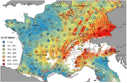
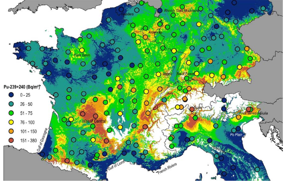
The study concludes that the caesium resulting from the nuclear tests - carried out in the stratosphere, i.e. at high altitude - circulated in the atmosphere before being brought down to the ground by the rains in a fairly homogeneous manner but with a slightly higher concentration in the rainiest regions, such as the Massif Central, the Ardennes or Brittany. On the other hand, the caesium released during the Chernobyl accident did not reach such altitudes; it remained at tropospheric level. The scattered rains that occurred in late April/early May 1986 quickly brought it back to the ground in areas where the plume from Ukraine had circulated. The spatial distribution of radioactive fallout is thus much more heterogeneous, with locally higher concentrations in Alsace, Franche-Comté and the foothills of the Alps, northern Italy and southern Germany.

Baseline inventories of Caesium 137 (0-20 cm) topsoil (Bq m-2) - corrected for radioactive decay as of August 1, 2009, estimated using a generalized additive model with 500 m resolution. In the study area, areas above 1000 m were masked out (white). © Scientific Reports

Baseline stocks of Plutonium 239+240 in the topsoil (0-20 cm) (Bq m-2) are estimated with an additive model with a resolution of 500 m. In the study area, areas above 1000 m elevation were masked out (white). © Scientific Reports

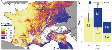
A. Contribution of Caesium 137 fallout from Chernobyl as % of soil samples (0-20cm) - corrected for radioactive decay to 2009.
Areas above 1000 m altitude were masked out (white).
B. Origin of Caesium 137 (PBq) from arable land in Western Europe. © Scientific Reports
Regarding health monitoring, radioactive fallout associated with nuclear tests and the Chernobyl accident currently contributes less than 1% of the average exposure dose of French citizens. More information are available on the
IRSN website.