ARISE 2, following the ARISE project, aims at establishing a unique atmospheric research and data platform in Europe. It combines observations with theoretical and modelling studies to improve our understanding of the dynamics of the middle and upper atmosphere. For the first time it associates the infrasound1 technology used for operational monitoring, related to the verification of the Comprehensive nuclear-Test-BanTreaty (CTBT), to other technologies such as LIDAR2, airglow cameras3, radars, microwave radiometry, ionospheric sounding and satellites for simultaneous observations in a complementary way.
The middle and upper atmosphere are affected by planetary and gravity waves at the origin of large scale disturbances such as Sudden Stratospheric Warming events which further play a role on weather up to several weeks. Information from this wave system and global dynamics, gathered through ARISE observations, is then crucial to be assimilated in short and medium range forecast models to improve future predictions to monthly or seasonal scales. In return, the better understanding of the atmosphere is relevant to improve data analysis for operational infrasound monitoring purposes. ARISE 2 proposes to design a new infrastructure that will integrate complementary observation networks and observatories to provide a new 3D image of the atmosphere in the different atmospheric layers from ground to mesosphere with unprecedented spatial-temporal resolution. The information collected will be centralized in a database providing a unique dataset for all scientists working on the Earth’s atmosphere.
Linking different global detection systems
The implied networks are:
- The infrasound network developed for the verification of the CTBT, the IMS4, completed by the European infrasound network composed of national stations and networks,
- The Network for the Detection of Atmospheric Composition Changes (NDACC) using LIDAR (LIght Detection And Ranging) measuring wind and temperature profiles completed by airglow cameras and spectrometers,
- Wind radiometers, infrasound stations located near volcanoes for volcanic sources studies,
- Meteor and MST radars,
- Ionospheric sounding arrays to determine coupling with near Earth space and satellite observations.
First multi-instrument comparisons during observations campaigns demonstrated significant differences between models and observations especially during stratospheric warming events. Such multi-instrument observations are relevant for improving the representation of stratospheric dynamics in models. ARISE 2 measurements are also used to improve the representation of gravity waves in stratosphere-resolving climate models, crucial to estimating the impact of a range of stratospheric climate forcing on the troposphere. In the next project steps, data will be assimilated in
models for a better accuracy in future medium-range weather forecasts. In the long term, the data will be used for monitoring of middle atmosphere climate, its long-term mean trends and changes in extreme events.
1 Infrasound waves are pressure waves at frequencies less than 20 Hz. They propagate over large distances in the atmospheric wave guided between the ground and the temperature increases of the stratosphere and thermosphere.
2 Lidar stands for light detection and ranging. It is a surveying method that measures distance to a target by illuminating that target with a laser light
3 Airglow is a faint emission of light by a planetary atmosphere. Scientific experiments have been conducted to induce airglow by directing high-power radio emissions at the Earth's ionosphere. These radiowaves interact with the ionosphere to induce faint but visible optical light at specific wavelengths under certain conditions.
4 The International Monitoring System (IMS) is a worldwide network of observational technology that will help to verify compliance with and detect and confirm violations of the CTBT.
Arising impacts for science and society
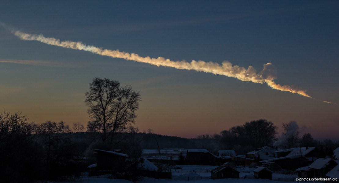
The ARISE data portal is dedicated to provide high quality, easy-to-use data and advanced data products to a wide scientific community. The ARISE 2 project contributes and leads to important advances in the field of atmospheric sciences extending from short-term impacts such as volcanic eruptions and climate related extreme events to long-term climate change with a great societal and commercial impact to Europe and beyond. Indeed, the monitoring of the Earth’s atmosphere with data from vanguard technologies offers a wide range of civil security applications that may possibly contribute to human welfare and safety. For instance, 20 infrasonic stations of the IMS have detected the infrasound returns – which travelled twice around the globe -generated by the huge meteor which exploded above Chelyabinsk in Russia on 15 February 2013. More recently, a meteorite crossed the Algerian sky on October 2016 and was observed up to 6 000 kilometers away by several infrasonic stations. Such observations allow to improve knowledge of the physical mechanisms involved in near-Earth object interaction with the atmosphere as well as the development of monitoring procedures to identify potentially dangerous exploding near-Earth objects.

A huge meteor flew over the Urals and exploded above Chelyabinsk city, Russia, on February 15, 2013. This photo was taken at about 200km distance by a local. © photos.cyberborean.org
Moreover, the global infrasound station density is steadily increasing and signals from remote volcanic activity are routinely recorded. The objective is to provide relevant parametrization of distant low-latency volcanic explosions. Such early warning systems may help to prevent eruption disasters and mitigate the impact of ash clouds on aviation. Similarly, the utilization of ARISE infrasound data to study natural hazards related to massive earth displacements (earthquakes, landslides and avalanches) or the evolution of extreme weather events (severe storms, tornadoes and cyclones) is also relevant for civil security applications.

Infrasound experiment at Yasur volcano,Tanna island / Vanuatu © IRD Noumea
About ARISE 2:
 |
ARISE 2 follows the ARISE project, which ran from Jan. 2012 to Dec. 2014. ARISE 2 will run until August 2018 and benefits from an EU grant amounting to 3.2 million €.
|
The first steps of ARISE made it possible to quantify the uncertainties of the wind and temperature models by inter-comparisons between observations and atmospheric models. The next step will be to optimize the use of ARISE data by the generalization of these inter-comparisons via the advanced products of the ARISE portal hosted by the CEA. Another step will be the development of the "Volcanic Parameter System” to provide, in relation with the CTBT organization, information to civil aviation characterizing the volcanic eruptions remotely detected by the infrasound network.
ARISE2 gathers 23 partners. Both ARISE and ARISE2 projects are coordinated by Elisabeth Blanc (CEA). |