Since the 1960s, South America (Brazil, Paraguay, etc.) has been undergoing a "Green Revolution" that is gradually transforming natural grasslands and forests into intensive farmland. This cropland then becomes more vulnerable to erosion, which, as it increases, disrupts downstream hydrological systems (river and reservoir siltation). Today, however, there is little quantitative data on these erosion processes and a debate is raging about their extent within the scientific community and among farmers.
To move forward, scientists propose to use a tracer: Cesium 137 (137Cs) resulting from the atmospheric nuclear tests. This radioactive isotope was deposited on soils during the 1960s and quickly and almost irreversibly bound to clay particles. The comparison between eroded and "intact" soils will make it possible to reconstruct a posteriori the rates of erosion over the last 60 years.
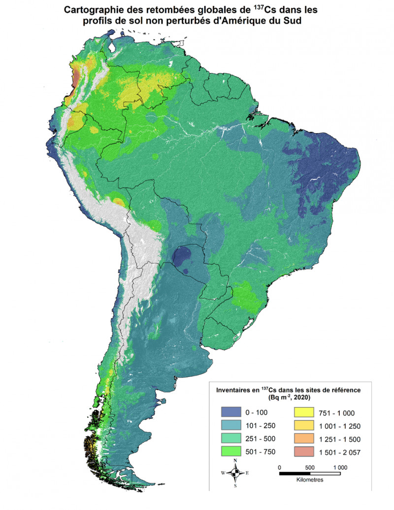
Accordingly, the most accurate map of cesium-137 deposition must first be established. For this purpose, there were 96 reference sites in South America - permanent grasslands on flat surfaces - whose soils have been analysed for 137Cs since the 1960s. Researchers have synthesized this published data and applied statistical processing using rainfall and geographical information (latitude and longitude) to reconstruct the deposition map for the entire subcontinent.
It should be noted that the spatial distribution of 137Cs deposition varies with latitude, with a maximum of 137Cs content in the 30-50° South latitude band, and levels are higher than those reported by UNSCEAR (United Nations Scientific Committee on the Effects of Atomic Radiation) from atmospheric measurements. These values are also high enough to detect 137Cs and study the redistribution of soils exposed to erosion in most countries.
Since the distribution of reference sites is heterogeneous, the scientists have also identified priority areas for future sampling to improve the spatial accuracy of the map of 137Cs deposition in soils (Andean foothills, Colombia, Peru, etc.).
The 137Cs inventory technique will allow the quantification of erosion in areas with vulnerable ecosystems threatened by the expansion of agricultural activities, particularly in southern Brazil, Uruguay, etc. The results of the 137Cs inventories will be used to quantify erosion in areas with vulnerable ecosystems threatened by the expansion of agricultural activities, particularly in southern Brazil, Uruguay, etc. It could also have many applications in Earth sciences, pedology (soil science) and climatology.
This work was carried out in collaboration with researchers from the National Research Institute for Agriculture, Food and the Environment (INRAE) and agronomists from universities in Brazil and Uruguay.
UNSCEAR: Sources and effects of ionizing radiation, United Nations Publications, New York, 2000.